

 Three Things Every Jew Needs to Hear at the Seder This Year


7 min read
Researchers have identified ancient military camps that correspond with the biblical narrative of King Sennacherib's siege.
When the Assyrian king Sennacherib ordered his artists to decorate the walls of his palace with scenes of his military victories, he did not suspect that thousands of years later, these wall reliefs would help modern day archeologists solve ancient mysteries.
Among Sennacherib’s palace reliefs are the Lachish reliefs, discovered in the 1840s by the British art historian Austen Henry Layard. Currently located in the British Museum in London, the reliefs depict the siege and capture of the city of Lachish in Biblical Judah.
Historians and archeologists have studied these reliefs for a century and a half, but it was only in 2004 that German archeologist Maria Micale and Italian archeologist Davide Nadali paid attention to the shape and structure of Sennacherib’s military camp depicted on the reliefs. They discovered that the camp was elliptical in shape and was divided into two or three sections on the inside, which contained the king’s royal quarters and the soldiers’ tents. The camp was surrounded by defensive walls1.
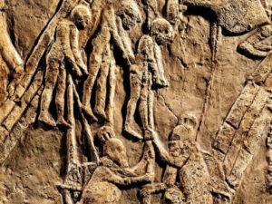
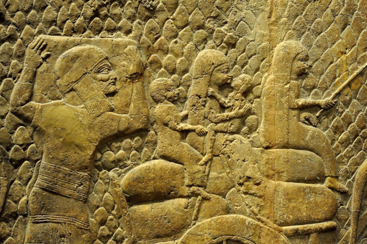 Judaean prisoners were deported into exile. Part of the Lachish Reliefs
Building on their discoveries, American archeologist Stephen Compton set out to look for archeological remains of King Sennacherib’s military camps throughout Israel. Recently, Compton published a scientific paper in a peer-reviewed journal, Near Eastern Archeology2.
Compton began his investigation with Lachish itself. Lachish was a fortified city located at the top of a hill. It had been previously thought that Sennacherib’s camp had been located at the bottom of the hill. However, no remains of a military camp were discovered there.
After a more careful look at the reliefs, Compton noticed that the camp seemed slightly farther away from Lachish, with another hill in between the Assyrian army and Lachish’s defendants. He began examining old aerial photographs of Lachish from 1945, before the area was built up.
Compton wrote3:
Expanding the search to the north and farther afield reveals the remains of an oval, walled structure… adjacent to the main ancient road, the Diagonal Route, which connected Lachish to Azekah. The structure’s long axis points toward Lachish, as does that of the camp in the relief. Likewise, as in the relief, a hill is positioned between Lachish and this structure but closer to the latter.
Compton further explains that on early maps, this location is labeled as Khirbet al Mudawwara – ruins of mudawwara. The word “mudawwara” in Medieval Arabic denotes “a large tent of rulers and great men, used especially when the army was on the march.”
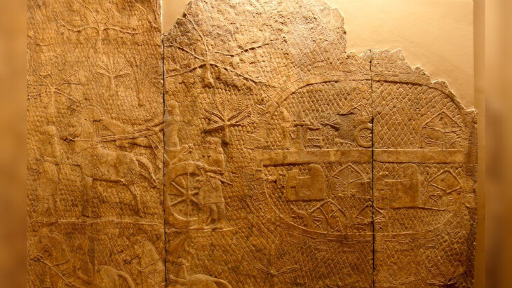 Stone panels commemorating the conquest of Lachish from the walls of the Assyrian Emperor Sennacherib’s palace show his military camp. The twenty-four guard towers in the camp’s perimeter wall, each with three windows visible, indicate a substantial fortification. S. C. Compton
When Compton checked the existing archeological records of Khirbet al Mudawwara, he saw that pottery sherds demonstrated a long period of inactivity, then “significant activity” about the time of Sennacherib’s invasion, and then again centuries of inactivity. These records further convinced Compton that this was the area of Sennacherib’s siege camp.
Next, Compton looked at Assyrian chronicles to see where else he might be able to find Sennacherib’s camps.
According to the chronicles, before invading Judah, Sennacherib conquered Philistia. He besieged four Philistine cities: Beth-Dagon, Joppa, Banaibarka, and Asuru. Compton found a site also referred to as mudawwara that is located in northern Philistia, in the area of these four cities, along a north-south road. The location is consistent with the chronicles’ description of the Assyrian army arriving from the north.
Compton continued his search for mudawwaras, tracing Sennacherib’s route of conquest. He found that Azekah, near today’s Beit Shemesh, was likely Sennacherib’s entry point into Judah. From there, Sennacherib besieged the fortified cities of Judah, listed in Chronicles II 11.
Lachish seems to be the southernmost city conquered by Sennacherib. Compton suggests that Sennacherib lingered at Lachish, as evidenced by his correspondence with King Hezekiah of Jerusalem that is dispatched to Lachish4.
After leaving Lachish, Sennacherib moved on to Libnah. Using the location of another mudawwara and other evidence, Compton argues that Libnah can be identified as Lavnin, today an Israeli national park.
The next encampment is to the southwest of Beit Shemesh. It is slightly different from the other ones because it is not located on top of its hill. Compton hypothesizes that the hill was too rugged. Instead, he writes5, “this mudawwara appears to correspond to an elongated plateau running north–south along the side of the hill, its perimeter lined with the remains of a dry-stone wall similar to that of the Lachish mudawwara.”
From Beit Shemesh, the trail of camps continues north, which is surprising. Both Biblical and Assyrian sources mention Sennacherib’s siege of Jerusalem, which is to the east of Beit Shemesh. However, until now, despite extensive research, no one was able to locate the site of the Assyrian siege camp.
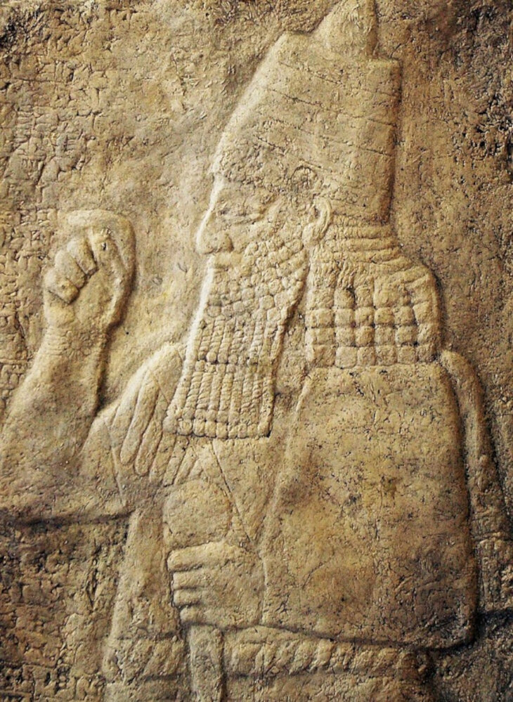 Cast of a rock relief of Sennacherib from the foot of Cudi Dağı, near Cizre.
Compton’s research proposes a solution to this riddle. He suggests that instead of following a direct path and approaching Jerusalem from the south, Sennacherib proceeded north and conquered several cities before turning around and heading back south toward Jerusalem. Perhaps Sennacherib’s strategy was to surprise King Hezekiah, who would have been expecting an attack from the south, by attacking from the north instead.
Thus, Compton decided to look for the siege camp north of Jerusalem. He writes6:
Looking farther north, the earliest aerial photographs of Jerusalem … show a structure similar to the Lachish mudawwara with the remains of substantial oval walls around both the base and the summit. The lower wall appears to have been far more substantial on the side facing Jerusalem, consistent with an adversarial relationship. The [1945] Survey of Palestine (SoP) Jerusalem map labeled this Jebel el Mudawwara, “Mountain of the Mudawwara.”
Previously, the ruins at Jebel el Mudawwara were thought to be from the Roman siege of Jerusalem in the 1st century CE. However, Compton demonstrates that Roman camps had been rectangular in shape rather than oval. Moreover, the size and structure of these ruins are very similar to the ones near Lachish. Compton suggests that the ruins at Jebel el Mudawwara are the remains of Sennacherib’s camp.
Another factor in support of Compton’s theory is that Isaiah7 mentions that Sennacherib encamped in Nob, a town north of Jerusalem, according to Nehemiah8. The exact location of Nob has also remained an enigma to archeologists until now. Compton suggests that Nob can be identified with Jebel el Mudawwara.
Today, Jebel el Mudawwara is known as the Ammunition Hill Heritage Site in Jerusalem. It received its name during the British Mandate, when the British built a police academy and an ammunition bunker at the site. In the Independence War of 1948, the hill was conquered by the Jordanians. In the Six Day War of 1967, after an intense battle, it was liberated by the Israeli paratroopers and reunited with the rest of Jerusalem.
It is known from history that Sennacherib did not manage to capture Jerusalem. According to Kings II9, he lost the war through a miracle. An angel visited the Assyrian encampment and struck 185,000 people. Sennacherib and the other survivors retreated to Assyria. Thus, Compton might have discovered the site of this miracle.


Bravo Compton.
Very interesting. And to think that "Ammunition Hill" is Nov, the city of Kohanim!